
Families - Brauneck to Benewand

The ropeway in Lenggries (www.brauneck-bergbahn.de) transports
us comfortably within 15 minutes over a height of 830m to the top
of the Brauneck. Costs: adults 8 euro, children 4 euro. operation
in summertime from 8.15 - 17.00 hrs.
With especially good condition a hiker has also the choice to hike
to the top on at least two variants:
a) direct rise near the trace of the ropeway passing Reiseralm -
Garlandalm (2.5 Std.),
b) on the high path direction Wegscheid - Schellenburg -
Jaudenstadl - (behind the Skilifts turn to the
right) - Kotalm - Brauneck (3 hrs).
Route Description
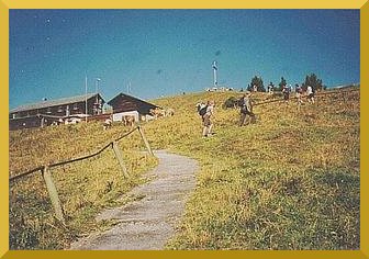
From the ropeway top-station we follow a broad way with full view,
leaving the top with the Brauneck-house to the right. The way leads
at first almost even to western direction. Short after a pasture
door we follow the signpost "Benediktenwand" and turn to the right.
The red-white-red sentinel escorts us the entire tour. A few 100m
after a lift-station and 50m after a sentinel "Tutzinger
Hütte" we turn to the right. From now on we follow until
further notice the sentinel 451 or E2.
Now the way leads steep upward and now and then we need our hands
to be sure. Further we hike on a ridge accompanied by spruces and
pines. There we have a nice view to the Ammersee and into the
Karwendel mountain group.
Over a second steep waypiece we come to the Stangeneck (1646m). We
have a look to the north in the Längental-valley and to the
south at the Idealhang-area. Here we see a column of sloping posts
which belong to the avalange demolition device of the skiing area.
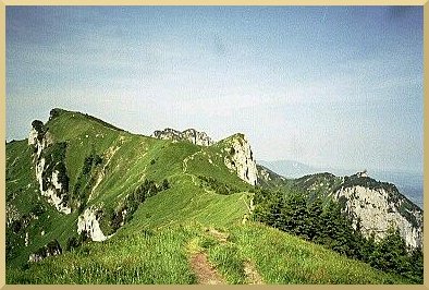
Soon on a slightly downgoing way we have a first view at the still
far away beeing Benediktenwand (center of picture, background); in
foreground (left) the Latschenkopf, to the right the stately
Kirchstein and in western direction behind the Probstenwand (very
right).
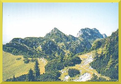
From the saddle we follow the signpost to the Benediktenwand. We
leave the steep rockwall of the Vorderer Kirchstein (1670m) and a
white memorial at the right and come to a terrace. We continue
hiking to the Latschenkopf (1712m) and enjoy the far view at Murnau
and the Staffelsee. Eventually we see the Walchensee and behind of
it the Zugspitze. Up to now a full hour hikingtime. Now we hike
about 90 meters downward to the Feichtecksattel (1626m) where we
come to a level crossing. From here we have two ways to the
Benediktenwand or the mountain hut Tutzinger Hütte. Else
farther straight along over the Acheslköpfe or right downward
passing the Achselköpfe northerly below.
The latter route is easier and leads from the Feichtecksattel to the west 200m downward direction Probstalm, then along the northern slopes and finally upwards to the Rotöhrl-Sattel where both routes unite. Because this variant often is wet and slippery we take the more pretentious route. But here absolute safe in giddiness and foothold is a prerequisite. Then the route is also possible for well exercised children from 7 years on. Regularly you should secure children with a rope. But one has experienced also a serious accident here, caused by the incautiousness of an adult. So be careful!
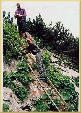
At first between low pines and meadows up and down. Then a short
not very serious iron ladder which is a prelude to the first
Achselkopf. The succession of the ups, downs and little tops you
can assort to four tops of which the second with 1709m is the
highest.In contrast to the others this second top will not be
directly overstepped but northerly bypassed below the top. The
hiking path always is clearly to be looked over.
More serious paces are secured with iron ropes. An inspiring up and
down flavoured by surprising views which can be topped by a little
break on one of the tops. With some luck we meet some of the ibexes
of this region. After the descend from the fourth top the route
leads a last time upward to the Rotöhr-Sattel (1615 m) which
we will eventually reach after about 2 1/2 hrs.
From here on the route signed with E4 and 456 leads along the
northern flank of the Benediktenwand within 45 minutes to the
mountain hut Tutzinger Hütte (1327m). Hiking time without
breaks from Brauneck about 3 1/4 hours.
He or she who is early and in a very good fettle can start from the
Rotöhr-Sattel via the steep iron-rope secured westrise to the
top of the Benediktenwand (1801m) and slow down along the smooth
path 455 to the mountain hut Tutzinger Hütte (hiking time
additional about 2 hrs).
short description:
height difference: Brauneck top station 1530 m, Tutzinger
Hütte 1327 m, highest pace 1712 m (Latschenkopf); with all ups
and downs about 450 m rise, about 650m descend.
duration: 3 1/4 hrs pure hiking time
charakter: diversified hiking tour with manifold near and
far views. the overcome of the Achselköpfe requires absolute
safe of giddiness and foodhold connected with experience in the
mountains.
children: well exercised children with experience in
climbing from 7 years on now and then secured by rope
endangerments: In case of possible thunderstorms avoid this
tour in any case because of the long distance on the ridge!